NECoM (Numerically Enhanced COnceptual Modelling) of two small Maltese Aquifers: Mizieb and Pwales
All claims expressed in this article are solely those of the authors and do not necessarily represent those of their affiliated organizations, or those of the publisher, the editors and the reviewers. Any product that may be evaluated in this article or claim that may be made by its manufacturer is not guaranteed or endorsed by the publisher.
Authors
Two small Maltese aquifers, Mizieb and Pwales, were numerically analyzed to test the existing hydrogeological conceptual model and suggest optimized groundwater monitoring strategies in support of the forthcoming monitoring network coordinated by the Government of Malta through the Energy and Water Agency. The model will undergo further revision of the concepts on which it is based as soon as new data is available, considering the conceptual and numerical model development as parallel activities, rather than as sequential. The model structure and parameter estimation made use of qualitative information and data acquired by archive research; during model calibration information/assumptions were introduced as "prior information" while the available measurements were introduced as classical "observations" with proper associated weight. The information content of both qualitative and quantitative data could be assimilated along the calibration process, highlighting the uncertainties and open questions that remain because of data insufficiency.
Altmetrics
Downloads
Citations


Borsi I, Foglia L, Cannata M, Vázquez-Suñé E, Mehl S, De Filippis G, Criollo R, Ghetta M, Cardoso M, Velasco V, Neumann J, Toegl A, Serrano A, Riera C, Rossetto R (2019) FREEWAT User Manual, Volume 0 - Reference Manual. Version 1.2.0, November 14th, 2019, http://www.freewat.eu/. Lat accessed October 2020.
Bureau de Recherche Géologique et Miniére - BRGM (1991) Study of the fresh-water resources of Malta. Water Works Department. Protocol number: R33691 EAU 4S 91. Energy and Water Authority archive, Malta.
Costain LTD (1958) Report on Geological Investigation of the Miziep Basin. Government of Malta - Water Supply, September 1958.
De Filippis G, Borsi I, Ghetta M, Rossetto R (2017) The FREEWAT platform for the assessment of water availability and quality. Acque Sotterranee - Italian Journal of Groundwater, 6(3/149):65-66, in Italian. doi:10.7343/as-2017-294.
Doherty J (2003) Groundwater model calibration using Pilot Points and Regularization. Ground Water. doi:10.1111/j.1745-6584.2003.tb02580.x
Doherty J (2008) Guidelines for groundwater model calibration using regularized inversion: Brisbane, Australia, Watermark Numerical Computing, 41 p., https://pesthomepage.org/. Last accessed October 2020.
Doherty J (2015) Calibration and Uncertainty Analysis for Complex Environmental Models. Watermark Numerical Computing, Brisbane, Australia. ISBN: 978-0-9943786-0-6
Doherty J, Fienen M, Hunt R (2010a) Approaches to highly parameterized inversion: Pilot-point theory, guidelines, and research directions: U.S. Geological Survey Scientific Investigations Report 2010-5168, https://pubs.usgs.gov/sir/2010/5168/pdf/sir20105168.pdf
Doherty J, Hunt R, Tonkin M (2010b) Approaches to highly parameterized inversion: A guide to using PEST for model-parameter and predictive-uncertainty analysis. U.S. Geological Survey Scientific Investigations Report 2010-5168, https://pubs.usgs.gov/sir/2010/5211/pdf/uncpest_sir2010-5211.pdf
Geological Survey of Great Britain GSGB (1945) Military Engineering: Water supply. Supplement No. 1. The location of underground water by geological and geophysical methods. War Office Code 7490. HMSO, London.
Harbaugh AW (2005) MODFLOW-2005, The U.S. Geological Survey modular ground-water model—the Ground-Water Flow Process: U.S. Geological Survey Techniques and Methods 6-A16.
Hill MC and Tiedeman CR (2007) Effective Groundwater Model Calibration: with Analysis of Data, Sensitivities, Predictions, and Uncertainty, John Wiley and Sons, New York. doi:10.1002/0470041080
Lang DM (1960) Soils of Malta and Gozo. Colonial Research Series N.29, London: HMSO.
Lotti F, Borsi I, Guastaldi E, Barbagli A, Basile P, Favaro L, Mallia A, Xuereb R, Schembri M, Mamo JA, Sapiano M (2021) Numerically enhanced conceptual modelling (NECoM) applied to the Malta Mean Sea Level Aquifer. Hydrogeology Journal, in press.
Morris TO (1952). The water supply resources of Malta. Government of Malta.
National Statistics Office - Malta - NSO (2019). News Release 108/2019, 10 July 2019, https://nso.gov.mt/en/News_Releases/View_by_Unit/Unit_C5/Population_and_Migration_Statistics/Documents/2019/News2019_108.pdf. Last accessed October 2020
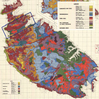
OED Oil Exploration Directorate, Office of the Prime Minister (1993) Geological Map of the Maltese Islands: Sheet 1- Malta.
Rose E (2012). Groundwater as a military resource: Development of Royal Engineers Boring Sections and British military hydrogeology in World War II. Geological Society of London Special Publications. 362. 105-138. 10.1144/SP362.7
Rossetto R, De Filippis G, Borsi I, Foglia L, Cannata M, Criollo R, Vázquez-Suñé E (2018) Integrating free and open source tools and distributed modelling codes in GIS environment for data-based groundwater management, Environmental Modelling & Software, 107:210-230. doi:10.1016/j.envsoft.2018.06.007
Royal Engineers (1952) Boreholes drill performed from 1943 - 1952 for groundwater resource exploration in Malta. Energy and Water Authority archive, Malta.
Rumbaugh J and Rumbaugh O (2020) Groundwater Vistas Version 7.24, Build 211. Environmental Simulations Inc., Reinholds, PA.
Stuart ME, Heaton THE, Maurice L, Chilton PJ and William PJ (2008) A preliminary study on the identification of the sources of nitrate contamination in groundwater in Malta Results and interpretation. British Geological Survey Commissioned Report, CR/08/094. 4pp.
Sustainable Energy and Water Conservation Unit - SEWCU (2015) The 2nd Water Catchment Management Plan for the Malta Water Catchment District 2015 - 2021. Environment and Resources Authority, Spencer Hill Marsa, Malta.
Thornthwaite CW, Mather JR (1955) The Water Balance. Publications in Climatology, Laboratory of Climatology, Vol. 8, No. 1, 104 pp.
USDA - Soil Survey Staff. (1999) Soil taxonomy: A basic system of soil classification for making and interpreting soil surveys. 2nd edition. Natural Resources Conservation Service. U.S. Department of Agriculture Handbook 436.
Viaroli S, Lotti F, Mastrorillo L, Paolucci V, Mazza R (2019) Simplified two dimensional modelling to constrain the deep groundwater contribution in a complex mineral water mixing area, Riardo Plain, southern Italy. Hydrogeology Journal (2019) 27:1459-1478. https://doi.org/10.1007/s10040-018-1910-3
Supporting Agencies
Energy and Water Agency of the Government of MaltaHow to Cite
PAGEPress has chosen to apply the Creative Commons Attribution NonCommercial 4.0 International License (CC BY-NC 4.0) to all manuscripts to be published.