Initial assessment of the groundwater flow and budget using Geographic Information System, MODFLOW-2005 and the FREEWAT modeling tool in Bouteldja coastal aquifer (Northern East of Algeria)
All claims expressed in this article are solely those of the authors and do not necessarily represent those of their affiliated organizations, or those of the publisher, the editors and the reviewers. Any product that may be evaluated in this article or claim that may be made by its manufacturer is not guaranteed or endorsed by the publisher.
Accepted: 25 September 2021
Authors
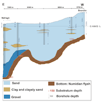
The Bouteldja coastal aquifer is one of the most important groundwater resources in North eastern of Algeria. The region is under a sub-humid climate with an average rainfall of 600-880 mm/y. The unconfined aquifer is constituted of Quaternary sands formations. The hydrogeological characteristics were determined based on previous reports. A very important inflow recharges the sandy aquifer in the Southeastern boundary, in relation to a fault network system linking the aquifer and the Obeira Lake area. Another inflow is observed at the Southern boundary in relation to the exchanges with the alluvial aquifer of Bouteldja. The purpose of the present study is to provide an initial assessment of the groundwater flow and water budget of this aquifer. To achieve this goal, a one-layer groundwater flow numerical model was developed using the MODFLOW-2005 code and the FREEWAT software, using the available data. The model was run in steady state conditions. Calibration was achieved using the piezometric measurements of May 2018 as calibration target. After several trials of manual calibrations, the model successfully simulated the groundwater flows directions and heads. Calibration efforts lead to an acceptable concordance (for the purpose of this study) between the estimated and calculated hydraulic conductivity and piezometric heads, except at the Eastern border. The analyses of the simulated inflow budget shows that aside the rainfall infiltration, exchanges with surface water bodies, the adjoining alluvial aquifer and the fault system provide a relevant amount of water. This significant recharge needs additional investigations. This numerical modeling exercise using MODFLOW, the FREEWAT software and GIS reached the objective of a preliminary description of the groundwater flow and it represents an acceptable starting point for more thorough hydrodynamic characterization of the Bouteldja coastal aquifer.
Downloads
Citations


How to Cite

This work is licensed under a Creative Commons Attribution-NonCommercial 4.0 International License.