Modeling groundwater/surface-water interactions and their effects on hydraulic barriers, the case of the industrial area of Mantua (Italy)
Accepted: 21 June 2022
All claims expressed in this article are solely those of the authors and do not necessarily represent those of their affiliated organizations, or those of the publisher, the editors and the reviewers. Any product that may be evaluated in this article or claim that may be made by its manufacturer is not guaranteed or endorsed by the publisher.
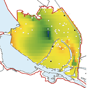
The town of Mantua is a good example of an urban area with an intricate surface water system leading to complex groundwater/surface-water interactions. In this context, the Site of National Interest (SIN) “Laghi di Mantova e Polo Chimico”, is characterized by intense pumping activity by means of industrial wells and hydraulic barriers. In order to establish the interactions between groundwater and the surface water system, evaluating their relation with the pumping activities, a transient groundwater numerical model was developed (January 2016 - December 2018) using MODFLOW-2005 and the Streamflow-Routing (SFR2) package, following a participatory approach. Results show how, depending on the minimum/ maximum groundwater conditions and the discharge values of the surface channels, the relation between groundwater/surface-waters can vary during the year, also affecting the operation of the hydraulic barriers. The stakeholders could use the calibrated model in the future to ensure optimal management of the pumping activities within the SIN.
ARPA Mantova (2019) Relazione Campagna Acque https://www.arpalombardia.it/sites/DocumentCenter/Documents/SIN%20Mantova/Relazione%20campagna%20acque%202019.pdf
ARPA Mantova (2017) Programma di interventi per la definizione dei plumes di contaminazione: Progetto Mantova Via Allende
Barlow PM, Leake SA (2012) Streamflow depletion by wells: understanding and managing the effects of groundwater pumping on streamflow. US Geological Survey Reston, VA DOI: https://doi.org/10.3133/cir1376
Bonomi T (2009) Database development and 3D modeling of textural variations in heterogeneous, unconsolidated aquifer media: Application to the Milan plain. Comput Geosci 35(1):134–145. https://doi.org/10.1016/j.cageo.2007.09.006 DOI: https://doi.org/10.1016/j.cageo.2007.09.006
Bonomi T, Fumagalli L, Rotiroti M, Bellani A, Cavallin A (2014) The hydrogeological well database TANGRAM©: a tool for data processing to support groundwater assessment. Acque Sotter - Ital J Groundw 3(2). https://doi.org/10.7343/as-072-14-0098 DOI: https://doi.org/10.7343/as-072-14-0098
Borsi I, Rossetto R (2012) L’utilizzo della modellistica nella gestione della risorsa idrica “Use of modeling in water resource management”. Acque sotterranee. Ital J Groundw (2/129):67–68
Buarnè F, Rotiroti M, Fumagalli L, Bonomi T (2016) Local refinement of a groundwater flow model aimed at assessing the environmental sustainability of a fish hatchery water supply. Rend Online Soc Geol Ital 39:105–108. https://doi.org/10.3301/ROL.2016.58 DOI: https://doi.org/10.3301/ROL.2016.58
Castilla-Rho JC (2017) Groundwater Modeling with Stakeholders : Finding the Complexity that Matters First Things First : We Are Dealing. 55(5). https://doi.org/10.1111/gwat.12569 DOI: https://doi.org/10.1111/gwat.12569
Chahoud A, Gelati L, Palumbo A, Patrizi G, Pellegrino I, Zaccanti G (2013) Groundwater flow model management and case studies in Emilia-Romagna (Italy). Acque Sotter - Ital J Groundw 2(1):59–73. https://doi.org/10.7343/AS-019-13-0043 DOI: https://doi.org/10.7343/as-019-13-0043
Consorzio di Bonifica Territori Mincio (2018) Piano Comprensoriale di Bonifica, di Irrigazione e di Tutela del Territorio Rurale
Dahl M, Nilsson B, Langhoff JH, Refsgaard JC (2007) Review of classification systems and new multi-scale typology of groundwater–surface water interaction. J Hydrol 344(1–2):1–16 DOI: https://doi.org/10.1016/j.jhydrol.2007.06.027
Feinstein DT, Buchwald CA, Dunning CP, Hunt RJ (2005) Development and application of a screening model for simulating
regional ground-water flow in the St. Croix river basin, Minnesota and Wisconsin. USGS Scientific Investigations Report 2005-5283.
Feinstein DT, Hunt RJ, Reeves HW (2010) Regional groundwater-flow model of the Lake Michigan Basin in support of Great Lakes Basin water availability and use studies. U. S. Geological Survey DOI: https://doi.org/10.3133/sir20105109
Ferré TPA (2017) Revisiting the Relationship Between Data, Models, and Decision-Making. Groundwater 55(5):604–614. https://doi.org/10.1111/gwat.12574 DOI: https://doi.org/10.1111/gwat.12574
Fetter CW (2001) Applied Hydrogeology. 4th ed, Prentice Hall, New Jersey.
Fienen MN, Juckem PF, Hunt RJ (2011) Simulation of the shallow groundwater-flow system near Mole Lake, Forest County, Wisconsin: U.S. Geological Survey Scientific Investigations Report 2011–5080, 9 p. DOI: https://doi.org/10.3133/sir20115080
Freeze AR, Cherry JA (1979) Groundwater. Prentice-Hall Inc. Prentice-Hall, Up Saddle River, NJ
Harbaugh AW (2005) MODFLOW-2005, the US Geological Survey modular ground-water model: the ground-water flow process. US Department of the Interior, US Geological Survey Reston, VA DOI: https://doi.org/10.3133/tm6A16
Kalbus E, Reinstorf F, Schirmer M (2006) Measuring methods for groundwater–surface water interactions: a review. Hydrol Earth Syst Sci 10(6):873–887 DOI: https://doi.org/10.5194/hess-10-873-2006
Lewandowski J, Meinikmann K, Krause S (2020) Groundwater-surface water interactions: Recent advances and interdisciplinary challenges. Water (Switzerland) 12(1):1–7. https://doi.org/10.3390/w12010296 DOI: https://doi.org/10.3390/w12010296
Lotti F, Borsi I, Guastaldi E, Barbagli A, Basile P, Favaro L, Mallia A, Xuereb R, Schembri M, Mamo JA, Demichele F, Sapiano M (2021)
NECoM (Numerically Enhanced COnceptual Modelling) of two small Maltese Aquifers: Mizieb and Pwales. Acque Sotter - Ital J Groundw 10(1):7–21. https://doi.org/10.7343/as-2021-496 DOI: https://doi.org/10.7343/as-2021-496
Middlemis H, Merrick N, Ross JB (2000) Groundwater Flow Modelling Guideline. Prepared for Murray-Darling Basin Commission by Aquaterra Consulting Pty Ltd. Project No. 125
Niswonger RG, Prudic DE (2005) Documentation of the Streamflow-Routing (SFR2) Package to Include Unsaturated Flow Beneath Streams - A Modification to SFR1 DOI: https://doi.org/10.3133/tm6A13
Paradigm (2009) Paradigm GOCAD 2009.1 User Guide. Paradigm, Houston, TX
Pollock DW (2016) User Guide for MODPATH Verison 7–a Particle Tracking Model for MODFLOW. Open-file Report 2016–1086. US Geol Surv Washington, DC MODPATH 7 DOI: https://doi.org/10.3133/ofr20161086
Regione Lombardia (2016) Banca dati geologica sottosuolo, Campioni Analisi Sondaggi Penetrometrie e Indagini Territoriali Ambientali (CASPITA) https://www.geoportale.regione.lombardia.it/download-dati Accessed 1 May 2020
Regione Lombardia (2021) Geoportal of the Lombardy Region, Italy http://www.geoportale.regione.lombardia.it/ Accessed 15 June 2020
Rumbaugh J, Rumbaugh O (2020) Groundwater Vistas Version 7.24, Build 211. Environ Simulations Inc, Reinholds, PA
Stefania GA, Rotiroti M, Fumagalli L, Simonetto F, Capodaglio P, Zanotti C, Bonomi T (2018) Modeling groundwater/surface-water interactions in an Alpine valley (the Aosta Plain, NW Italy): the effect of groundwater abstraction on surface-water resources. Hydrogeol J 26(1):147–162. https://doi.org/10.1007/s10040-017-1633-x DOI: https://doi.org/10.1007/s10040-017-1633-x
Wilson JD, Naff RL (2004) MODFLOW 2000: The US Geological Survey Modular Ground-water Model--GMG Linear Equation Solver Package Documentation. US Geological Survey, 2004. DOI: https://doi.org/10.3133/ofr20041261
Copyright (c) 2022 the Author(s)
This work is licensed under a Creative Commons Attribution-NonCommercial 4.0 International License.
PAGEPress has chosen to apply the Creative Commons Attribution NonCommercial 4.0 International License (CC BY-NC 4.0) to all manuscripts to be published.