Identification and mapping of potential recharge in the Middle Seybouse sub-catchment of the Guelma region (North East of Algeria): contribution of remote sensing, multi-criteria analysis, ROC-Curve and GIS


Submitted: 13 January 2023
Accepted: 20 March 2023
Published: 31 March 2023
Abstract Views: 961
PDF: 486
Publisher's note
All claims expressed in this article are solely those of the authors and do not necessarily represent those of their affiliated organizations, or those of the publisher, the editors and the reviewers. Any product that may be evaluated in this article or claim that may be made by its manufacturer is not guaranteed or endorsed by the publisher.

Authors

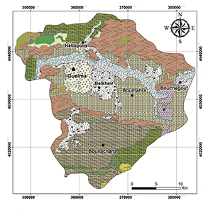
Due to the rapid population increase in the Middle Seybouse sub-catchment area in North-East Algeria, the intense agricultural practices, and the industrial development, precious water resources proven to be significantly challenged in their sustainable exploitation both in terms of quantity and quality. The aim of this study is to identify the most suitable areas for groundwater recharge in the Middle Seybouse sub-catchment, over about 770.91 km², using remote sensing data and Geographical Information Systems (GIS). Six factors are recognized to positively affect groundwater recharge: rainfall, land cover, topography, drainage density, lineament density, and lithology. According to their level of involvement in the recharge process, these parameters have been reclassified and then evaluated using the multi-criteria analysis known as “Analytical Hierarchy Process” (AHP). A potential recharge map of the study area was produced showing that 60% of this area, located in the southern and central parts of the catchment, has a high to very high potential. ROC (receiver operating characteristic) curve is used to validate the resulting groundwater potential recharge map using the existing wells in the study area.


Agency of Hydrographic Basin, (2005). The groundwater in the Seybouse basin, internal report, 1- 46.

Aissaoui, M. (2018).Hydrochemical characteristics of the Seybouse River and its tributaries in the Guelma region – quantifying the degree of pollution. Doctoral thesis, Badji Mokhtar University. Available online at: https://biblio.univ-annaba.dz/wp-content/ uploads/2019/10/These-Aissaoui-Marwa.pdf– last access 22/03/2023

Ake, G.E., Kouame, K.J., KOffi, A.B., & Jourda, J.P. (2018). Cartography of potential recharge areas of the Bonoua aquifer (south-eastofIvory Coast).Revue des Sciences de l’Eau/ Journal of Water Science. 31(2), 129-144.https://doi.org/10.7202/1051696ar DOI: https://doi.org/10.7202/1051696ar

Aouragh, M.H., Essahlaoui, A., El Ouali, A., El Hmaidi, A., & Kamel, S. (2017). Groundwater potential of Middle Atlas plateaus, Morocco, using fuzzy logic approach, GIS and remotesensing. Geomat Nat HazRisk 8:194–206. https://doi.org/10.1080/19475705.2016.1181676. DOI: https://doi.org/10.1080/19475705.2016.1181676

Arulbalaji, P., Padmalal, D., Sreelash, K. (2019). GIS and AHP techniques based delineation of groundwater potential zones: a case study from southern Western Ghats, India. Sci Rep 9(1):2082. DOI: https://doi.org/10.1038/s41598-019-38567-x

Baudron, P., Alonso-Sarría, F., García-Aróstegui, J.L., Cánovas-García, F., Martínez-Vicente, D., Moreno-Brotóns, J. (2013). Identifying the origin of groundwater samples in a multi-layer aquifer system with Random Forest classifcation. J Hydrol 499:303–315. https://doi. org/10.1016/j.jhydrol.2013.07.009. DOI: https://doi.org/10.1016/j.jhydrol.2013.07.009

Benmarce, K. (2015). Physico-chemical characterization of groundwater in the Guelma region, northeast Algeria. Doctoral thesis, Badji Mokhtar-Annaba University.

Brahmia, N. (2019). Assessment and integrated management of water resources in the Middle Seybouse watershed. Doctoral thesis, BadjiMokhtar University. Available online at: https://biblio.univ- annaba.dz/wp-content/uploads/2017/04/These-Brahmia-Nabil. pdf– last access 22/03/2023.

Boukheir, N., Abdallah, C., & Khawlie, M. (2008). Assessing soil erosion in Mediterranean karst landscapes of Lebanon using remote sensing and GIS.Engineering Geology, 99(3-4), 239-254. https:// doi.org/10.1016/j.enggeo.2007.11.012. DOI: https://doi.org/10.1016/j.enggeo.2007.11.012

Chabane, S., Amri, K., Hamdidouche, R. (2019). Deformation pattern in the El Ahmar area (Bechar Basin, southwestern Algeria): contribution of Lansat 8 OLI and field Measurement. Arabian Journal of Geosciences, 12, 158.https://doi.org/10.1007/s12517- 019-4311-6 DOI: https://doi.org/10.1007/s12517-019-4311-6

Chen, W., Pradhan, B, Li, S., Shahabi, H., Rizeei, H.M., Hou, E., & Wang, S. (2019). Novel hybrid integration approach of bagging- based fisher’s linear discriminant function for groundwater potential analysis. Nat Resoures 28:1239. https://doi.org/10.1007/ s1105 3-019-09465-w DOI: https://doi.org/10.1007/s11053-019-09465-w

Conforti, M., Aucelli, P.C., Robustelli, G., & Scarciglia, F. (2011). Geomorphology and GIS analysis for mapping gully erosion susceptibility in the Turbolo stream catchment (Northern Calabria, Italy). Natural Hazards, 56, 881-898. https://doi.org/10.1007/s11069-010-9598-2. DOI: https://doi.org/10.1007/s11069-010-9598-2

Cook, P.G., & Robinson, N.I. (2002). Estimating groundwater recharge in fractured rock from environmental 3H and 36Cl, Clare Valley, South Australia. Water Resources Research, 38(8), 1136. https:// doi.org/10.1029/2001WR000772. DOI: https://doi.org/10.1029/2001WR000772

Cook, P.G., Lamontagne, S., Berhane, D., & Clark, J.F. (2006). Quantifyinggroundwaterdischargeto Cockburn River, Southeastern Australia, using dissolved gas tracers 222Rr and SF6. Water Resources, 42, W10411. https://doi.org/10.1029/2006WR004921. DOI: https://doi.org/10.1029/2006WR004921

Das, S., & Pardeshi, S.D. (2018). Integration of different influencing factors in GIS to delineate groundwater potential areas using IF and FR techniques: a study of Pravarabasin, Maharashtra, India. Applied Water Sciences, 8, 197. https://doi.org/10.1007/s13201-018-0848-x. DOI: https://doi.org/10.1007/s13201-018-0848-x

Das, S. (2019). Comparison among infuencing factor, frequency ratio, and analytic alhierarchy process techniques for groundwater potential zonation in Vaitarna basin. Groundw Sustain Dev, Maharashtra. https://doi.org/10.1016/j.gsd.2019.03.003. DOI: https://doi.org/10.1016/j.gsd.2019.03.003

Garouni, E.A., & Merzouk, A. (2006). Demarcation of the protection zones around Hachef dam (Morocco) by remote sensing and GIS (in French). Journal of Water Science, 19, 4-10. DOI: https://doi.org/10.7202/012170ar

Gleeson, T. (2009). Groundwater recharge, flow and discharge in large crystallinewatershed. PhD Thesis, Civil Engineering Department, Queen’s University, Kingston, Ontario, Canada.pp. 251. Available online at:https://www.collectionscanada.gc.ca/obj/thesescanada/vol2/002/NR65317.PDF?is_thesis=1&oclc_number=772685337 – last access 22/03/2023

Hayashi, M., Vander Kamp, G., Schmidt, R. (2003). Focused infiltration of snowmelt water in partially frozen soil under small depressions. Journal of Hydrology 270:214–229. https://doi.org/10.1016/S0022-1694(02)00287-1. DOI: https://doi.org/10.1016/S0022-1694(02)00287-1

Healy, R., Cook, P. (2002). Using groundwater levels to estimate recharge. Hydrogeology Journal, 10, 91-109. https://doi.org/10.1007/s10040-001-0178-0. DOI: https://doi.org/10.1007/s10040-001-0178-0

Hou, E., Wang, J., Chen, W. (2018). A comparative study on groundwater spring potential analysis based on statistical index, index of entropy and certainty factors models. Geocarto Int 33:754– 769. https://doi.org/10.1080/10106049.2017.1299801. DOI: https://doi.org/10.1080/10106049.2017.1299801

Jenifer, M.A., Jha, M.K (2017). Comparison of analytic hierarchy process, catastrophe and entropy techniques for evaluating groundwater prospect of hard-rock aquifer systems. J Hydrol 548:605–624. https://doi.org/10.1016/j.jhydrol.2017.03.023. DOI: https://doi.org/10.1016/j.jhydrol.2017.03.023

Jourda, J.P. (2007). Assessment of the degree of protection of groundwater:vulnerability to pollution of the Bonouaaquifer (south-east of Ivory Coast) by theDRASTIC method. Conferenceproceedings Francophone ESRI, 10-11 October 2007, Versailles, France, 18 p.

Kaliraj, S., Chandrasekar, N., Magesh, N.S. (2014). Identifcation of potential groundwater recharge zones in Vaigai upper basin, Tamil Nadu, using GIS-based analytic alhierarchical process (AHP) technique. Arab J Geosci 7:1385–1401. https://doi.org/10.1007/s12517-013-0849-x DOI: https://doi.org/10.1007/s12517-013-0849-x

Kordestani, M.D., Naghibi, S.A, Hashemi, H., Ahmadi, K., Kalantar, B, Pradhan, B. (2019). Groundwater potential mapping using a noveldata-mining ensemble model. Hydrogeol J 27:211–224. https://doi.org/10.1007/s10040-018-1848-5 DOI: https://doi.org/10.1007/s10040-018-1848-5

Kord, M., Moghaddam, A.A. (2014). Spatial analysis of Ardabil plain aquifer potable ground water using fuzzy logic. J King Saud UnivSci 26:129–140. https://doi.org/10.1016/j.jksus.2013.09.004. DOI: https://doi.org/10.1016/j.jksus.2013.09.004

Kouadio, E.K., Savane, I., Lasm,T., & Beimi, J. (2008). Hydrogeology Prospecting in Crystalline and Metamorphic Areaby Spatial Analysis of Productivity Potential. European Journal of Scientific Research, ISSN 1450-216X, pp.373-390.

Koudou, A., Adiaffi, B., Assoma, T.V., Sombo, A.P., Amani, E., & Biemi, J. (2013). Concept of a decision-making tool for the groundwater prospecting in hard rock area; Southeast of Ivory Coast. Revue Geo-Eco-Trop, 37(2), 211-226.

Laraba, A., Hadj Zobir, S. (2009). Organic Pollution of the SeybouseWadi (Alluvial Plain Of Guelma, North-East Algeria). INCT Geographic Sciences Bulletin, 13(1), 2-6.

Latifi, S.,& Chaab, S. (2017). Assessmentand mappingof the vulnerability to pollution of the groundwater, using the both DRASTIC and GOD methods, in alluvial plain of Guelma, NorthEast of Algeria. Journal of Science and technology Synthese, 34, 48-62. www.univ- annaba.dz. ISSN : 111-4924. Lee, S., Kim, Y.S, Oh. H,J. (2012a).

Application of a weights-of-evidencemethod and GIS to regional ground water productivity potential mapping. J Environ Manage 96:91–105. https://doi.org/10.1016/j. jenvman.2011.09.016. DOI: https://doi.org/10.1016/j.jenvman.2011.09.016

Lentini, A., Meddi, E., Galve, J. P., Papiccio, C., & La Vigna, F. (2022). Preliminary identification of areas suitable for Sustainable Drainage Systems and Managed Aquifer Recharge to mitigate stormwater flooding phenomena in Rome (Italy). Acque Sotterranee - Italian Journal of Groundwater, 11(4), 43–53. https://doi.org/10.7343/as-2022-590 DOI: https://doi.org/10.7343/as-2022-590

Maizi, D., Boufekane, A., AitOuali, K., & Aoudia, M. (2020). Identification of potential area of recharge using geospatial and multicriteria decision analysis in the Macta watershed (Western Algeria). Arabian Journal of Geosciences, 13, 127. https://doi.org/10.1007/s12517-020-5076-7. DOI: https://doi.org/10.1007/s12517-020-5076-7

Manap , M.A, Nampak, H., Pradhan, B., Lee, S., Sulaiman, W.N.A, Ramli, M.F. (2014). Application of probabilistic-based frequency ratio model in ground water potential mapping using remote sensing data and GIS. Arab J Geosci 7:711–724. https://doi.org/10.1007/s12517-012-0795-z. DOI: https://doi.org/10.1007/s12517-012-0795-z

Mandal, U., Sahoo, S., Munusamy, S.B, Dhar, A., Panda, S.N, Kar, A., Mishra, P.K. (2016). Delineation of groundwater potential zones of coasta lgroundwater basin using multi-criteria decision making technique. Water Resour Manage 30:4293–4310. https://doi.org/10.1007/s11269-016-1421-8 DOI: https://doi.org/10.1007/s11269-016-1421-8

Mogaji, K.A, Omosuyi, G.O, Adelusi, A.O, Lim, H.S. (2016). Application of GIS-based evidential belieffunction model to region alground water recharge potential zones mapping in hardrock geologic terrain. Environ Pro 3:93–123. https://doi.org/10.1007/ s40710-016-0126-6 DOI: https://doi.org/10.1007/s40710-016-0126-6

Naghibi, S.A., Pourghasemi , H.R., Pourtaghi , Z.S., Rezaei , A. (2015). Ground water qanat potential mapping using frequency ratio and Shannon’s entropy models in the Moghan watershed, Iran. Earth SciInform 8:171–186. https://doi.org/10.1007/s1214 5-014-0145-7. DOI: https://doi.org/10.1007/s12145-014-0145-7

Naghibi, S.A, Ahmadi, K ., Daneshi, A. (2017). Application of support vector machine, randomforest, and genetic algorithm optimizedr and omforest models in ground water potential mapping. Water Resour Manage 31:2761–2775. https://doi.org/10.1007/s1126 9-017-1660-3. DOI: https://doi.org/10.1007/s11269-017-1660-3

Naseef, T.A.U., &Thomas, R. (2016).Identification of suitable sites for water harvesting structures in Kecheri River basin. Procedia Technology, 24, 7-14. https://doi.org/10.1016/j.protcy.2016.05.003. DOI: https://doi.org/10.1016/j.protcy.2016.05.003

National Water Resources Agency (NWRA). 2009. Lithological map of Guelma.

Nayak, P.C, Rao, Y.S, Sudheer, K.P. (2006). Groundwater levelforecasting in a shallow aquifer using artifcial neural network approach. Water Resour Manage 20:77. https://doi.org/10.1007/ s1126 9-006-4007-z DOI: https://doi.org/10.1007/s11269-006-4007-z

Nouayti, N., & Hilali, D.K.M. (2017). Potential areas mapping for the groundwater storage in the high Ziz basin (Morocco): Contribution of remote sensing and geographic information system. Bulletin de l’Institut Scientifique, Rabat. Section Sciences de la Terre, 39,45-57. e-ISSN: 2458-7184.https://doi.org/cabdirect/abstract/20193155553.

Neji, N., Ayed, R.B. & Abida, H. (2021). Water erosion hazard mapping using analytic hierarchy process (AHP) and fuzzy logic modeling: a case study of the Chaffar Watershed (South easternTunisia). Arabian Journal of Geosciences, 14, 1208. https://doi.org/10.1007/s12517-021-07602-5. DOI: https://doi.org/10.1007/s12517-021-07602-5

Oularé, S., Kouamé, K.F., Saley, M.H., & Ake, E.G. (2014). Estimation and validation of the depth of the aquifers of the N’zobasin, in Côte d’Ivoire, by the WTR model. Physio-Géo, 8, 1-25. http://doi.orgi10.4000/physio-geo.3752. DOI: https://doi.org/10.4000/physio-geo.3752

Pande, C.B, Moharir, K.N, Singh, S.K, Varade, A.M. (2019). An integratedapproach to delineate the groundwater potential zones in Devdari watershed area of Akola district, Maharashtra, CenralIndia. Environ Dev Sustain. https://doi.org/10.1007/s1066 8-019-00409-1.

Pinto, D., Shrestha, S., Babe, l M.S, Ninsawat, S. (2017). Delineation of ground water potential zones in the Comoro watershed, Timor Leste using GIS, remote sensing and analytic hierarchy process (AHP) technique. Appl Water Sci 7:503–519. https://doi. org/10.1007/s13201-015-0270-6. DOI: https://doi.org/10.1007/s13201-015-0270-6

Patra, S., Mishra, P., Mahapatra, S.C. (2018). Delineation of groundwater potential zone for sustainable development: a case study from Ganga Alluvial Plain covering Hooghly district of India using remote sensing, geographic information system and analytic hierarchy process. J Clean Prod 172:2485–2502. https:// doi. org/10.1016/j.jclepro.2017.11.161. DOI: https://doi.org/10.1016/j.jclepro.2017.11.161

Pourghasemi, H.R., Pradhan, B., Gokceoglu, C., Mohammadi, M., & Moradi, H.R. (2012).Application of weights-of-evidence and certainty factor models and their comparison in landslide susceptibility mapping at Haraz watershed, Iran.Arabian Journal of Geosciences, 6, 2351-2365. https://doi.org/10.1007/s12517-012-0532-7. DOI: https://doi.org/10.1007/s12517-012-0532-7

Pourghasemi, H.R, Beheshtirad, M. (2015). Assessment of a data- drivenevidentialbelieffunction model and GIS for groundwater potential mapping in the Koohrang Watershed, Iran. Geocarto Int 30:662–685. https://doi.org/10.1080/10106049.2014.966161. DOI: https://doi.org/10.1080/10106049.2014.966161

Praamsma, T.W., Novakowski, K.S., Kyser, T.K., Hall, K. (2009). Using stable isotope and hydraulic head data to investigate groundwater recharge and discharge in a fractured rock aquifer. Journal of Hydrology, 366, 35-45. https://doi.org/10.1016/j. jhydrol.2006.03.032. DOI: https://doi.org/10.1016/j.jhydrol.2008.12.011

Pradhan, B. (2010). Remote sensing and GIS-based landslide hazard analysis and cross-validation using multivariate logistic regression model on three test areas in Malaysia. Advances in Space Research, 45(10), 1244-1256.https://doi.org/10.1016/j.asr.2010.01.006 DOI: https://doi.org/10.1016/j.asr.2010.01.006

Rahmati, O., Samani, A.N., Mahdavi, M., Pourghasemi, H.R., Zeinivand, H, (2015). Groundwater potential mapping at Kurdistan region of Iran using analytic hierarchy process and GIS. Arab J Geosci 8:7059–7071. https://doi.org/10.1007/s12517-014-1668-4. DOI: https://doi.org/10.1007/s12517-014-1668-4

Ramaswamy, S.M., & Anbazhagan, S. (1997). Criteria and techniques of detecting site-specific mechanisms for artificial-recharge: a case study from Ayyar basin, India. Journal of the Geological Society of India, 50(4), 449-456

Razavi-Termeha, S.V., Sadeghi-Niaraki A., & Choi S.-M. (2020). Gully erosion susceptibility mapping using artificialintelligence and statistical models. Geomatics, Natural Hazards and Risk, 11, 821- 844. https://doi.org/10.1080/19475705.2020.1753824. DOI: https://doi.org/10.1080/19475705.2020.1753824

Ribeiro, A.S. ,Almeida, M.C., Cox, M.G., Sousa, J.A., Martins, L., Loureiro, D, Brito, R., Silva,M. &S oares, A.C. (2021). Role of measurement uncertainty in the comparison of averagearealrainfall methods. Metrologia, 58(4), 044001. https://doi.org/10.1088/1681-7575/ac0d49 DOI: https://doi.org/10.1088/1681-7575/ac0d49

Rizeei HM, Azeez OS, Pradhan B, Khamees HH (2018). Assessment of groundwater nitrate contamination hazard in a semi-arid region by using integrated parametric IPNOA and data-driven logistic regression models. Environ Monit Assess 190:633. https ://doi. org/10.1007/s10661-018-7013-8 DOI: https://doi.org/10.1007/s10661-018-7013-8

Rodhe, A., & Bockgard, N. (2006). Groundwater recharge in a hard rock aquifer: a conceptual model including surface-loading effects. Journal of Hydrology, 330, 389-401.https://doi.org/10.1016/j. jhydrol.2006.03.032. DOI: https://doi.org/10.1016/j.jhydrol.2006.03.032

Saaty, T.L. (1980). The analytic hierarchy process: planning, priority setting, resource allocation. Mc Graw-Hill, New York, NY, États- Unis, 19p.

Saha,S., Gayen, A., Pourghasemi, H.R & Tiefenbacher, J.P. (2019). Identification of soil erosion-susceptible areas using Fuzzy logic andanalytical hierarchy process modeling in an agricultural watershed of Burdwandistrict,India. Environ Earth Sciences, 78, 649. https://doi.org/10.1007/s12665-019-8658-5. DOI: https://doi.org/10.1007/s12665-019-8658-5

Saley, M.B. (2003). Hydrogeological information system with spatial reference, pseudo-image discontinuities and thematic maps of water resources in the semi-mountainous region of Man (western Côte d’Ivoire). Doctoral thesis, Univ. Cocody, Côte d’Ivoire, 195 p.

Sanford, W. (2002). Recharge and groundwater models: an overview. Hydrogeology Journal, 10(1), 110-120. https://doi.org/10.1007/s10040-001-0173-5 DOI: https://doi.org/10.1007/s10040-001-0173-5

Scanlon, B.R., Cook, P.G. (2002). Chooses appropriate techniques for quantifying groundwaterrecharge, Hydrogeology Journal, 10, 18-39. https://doi.org/10.1007/s10040-001-0176-2. DOI: https://doi.org/10.1007/s10040-001-0176-2

Shaban, A. (2003). Study of the hydrogeology of western Lebanon: Use of remote sensing.Doctoral thesis, Bordeaux 1 University, 202 pp. Available online at: https://www.scirp.org/(S(lz5mqp453edsnp55rrgjct55))/reference/ReferencesPapers. aspx?ReferenceID=1501379 – last access 22/03/2023.

Shaban, A., Khawlie, M., Abdallah, C. (2006). Use of remote sensing and GIS to determine recharge potential zone: the case of occidental Lebanon. Hydrogeology Journal, 14, 433-443.https://doi.org/10.1007/s10040-005-0437-6. DOI: https://doi.org/10.1007/s10040-005-0437-6

Swagata, B., Bhabani, P.M, Amit, B. (2020). Delineating groundwater potential zones of agriculture dominated land scapes using GIS based AHP techniques: a case study from Uttar Dinajpur district, West Benga. https://doi.org/10.1007/s12665-020-09053-9. DOI: https://doi.org/10.1007/s12665-020-09053-9

Tahmassebipoor, N., Rahmati, O., Noormohamadi, F., Lee, S. (2016). Spatial analysis of groundwater potential using weights-of-evidence and evidential belief function models and remotesensing. Arab J Geosci 9:79. https://doi.org/10.1007/s12517-015-2166-z. DOI: https://doi.org/10.1007/s12517-015-2166-z

United States Geological Survey (USGS). (2017). https://earthexplorer. usgs.gov

Wilson, S.R., Close, M.E., Abraham, P. (2018). Applying linear discriminant analysis to predict groundwater redox conditions conducive to denitrifcation. J Hydrol 556:611–624. https://doi. org/10.1016/j.jhydrol.2017.11.045. DOI: https://doi.org/10.1016/j.jhydrol.2017.11.045

Moussa Benhamza, Laboratory of Geodynamics and Natural Resources, University Badji Mokhtar-Annaba


Aissaoui, M., Maizi, D., Benhamza, M., Azzouz, K., Belaroui, A., & Bengusmia, D. (2023). Identification and mapping of potential recharge in the Middle Seybouse sub-catchment of the Guelma region (North East of Algeria): contribution of remote sensing, multi-criteria analysis, ROC-Curve and GIS. Acque Sotterranee - Italian Journal of Groundwater, 12(1), 25–37. https://doi.org/10.7343/as-2023-628

Downloads

Download data is not yet available.

Citations