Groundwater features in Hoedh el Chargui, Mauritania
Accepted: 23 December 2020
All claims expressed in this article are solely those of the authors and do not necessarily represent those of their affiliated organizations, or those of the publisher, the editors and the reviewers. Any product that may be evaluated in this article or claim that may be made by its manufacturer is not guaranteed or endorsed by the publisher.
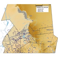
The Hodh el Chargui, a region located in the south-east of the Mauritania at 1000 km to the capital city of Nouakchott, is one of the poorer and remoter areas of the country. It is characterised by hard and in rural environment. Farmers and agro-pastoralists are the main economic actors and completely depend on natural resources. A specific project entitled "Reducing Agro-pastoral Vulnerability and Improving Resilience in Hodh el Chargui", funded by European Union, has been implemented in the Program "Institutional Strengthening in Mauritania towards Agricultural and Pastoral Resilience (RIMRAP)". The aims of the project are the strengthening of the resilience of Hodh el Chargui communities and the reduction of their vulnerability to crisis, assuring access to natural resources and their sustainable use. In particular, the water resource is fundamental to assure the development of the traditional agricultural and pastoral activities and guarantee proper health conditions. The present study reports the results obtained from a census of the well in the Hodh el Chargui, their distribution in the region and the main features of groundwater resource.
PAGEPress has chosen to apply the Creative Commons Attribution NonCommercial 4.0 International License (CC BY-NC 4.0) to all manuscripts to be published.