Assessing the Impact of land-use types on the groundwater quality: a case study of Mid River Njoro Catchment, Kenya
All claims expressed in this article are solely those of the authors and do not necessarily represent those of their affiliated organizations, or those of the publisher, the editors and the reviewers. Any product that may be evaluated in this article or claim that may be made by its manufacturer is not guaranteed or endorsed by the publisher.
Accepted: 7 September 2020
Authors
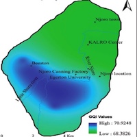
The study assessed the impact of land-use types on the groundwater quality of the mid River Njoro catchment, Kenya. Groundwater samples were collected from eight boreholes between the period of October 2017 to February 2018 and analyzed for pH, temperature, electrical conductivity, dissolved oxygen, nitrate, ammonium, and total phosphorus. These parameters were used to calculate the Groundwater Quality Index (GQI) value of the study area. The concentration maps ("primary maps I") were constructed using Kriging interpolation of ArcGIS software from the seven groundwater quality parameters. The "primary maps I" were standardized with the KEBS and WHO standards to the "primary maps II" for ease of integration into a GIS environment. The "primary maps II" were then rated and weighted using a polynomial function to generate "rank maps" before calculating the GQI using spatial analyst tools of ArcGIS software. The land use map was prepared from a high-resolution Google earth satellite imagery of 2015. The mean GQI values for the different land use polygons were calculated and compared using GIS techniques. The GQI ranged from 68.38 to 70.92, indicating a high groundwater quality of mid River Njoro catchment. The major land-use types identified include settlement area, forest cover, agricultural land and mixed area. The agricultural land dominated the study area, followed by settlement area, forest cover and finally mixed area. The mean GQI value in each land use type varied minimally and this could be because of the diffuse nature of the land use types of the study area. Settlement area had low GQI, followed by agricultural land, mixed area and the forest cover had the highest mean GQI value, which corresponds to good quality of groundwater. Even though the variation is insignificant in this particular study, it somehow indicates the adverse effects of different land use on the quality of groundwater.
Downloads
Citations


How to Cite

This work is licensed under a Creative Commons Attribution-NonCommercial 4.0 International License.